save the Blue Tier
tourism - tasmania
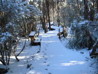
Part of the Goblin Forest Walk at Poimena powdered after the rare snowfall in September 2004; wombat tracks are visible in the foreground.
hiking on the blue tier of tasmania
Friends of the Blue Tier disagree with Forestry Tasmania's feasibility study on the Blue Tier giant tree walk and provide a report on a 7-day hike undertaken in February 2006.
The few resident locals are not really into the tourism thing. You're likely to get a laconic "Wander around" if you're misguided enough to seek information from the natives.
So we've just popped down to the St. Helens History Room and ripped off their walking guide (thanks for the permission). Here it is, unabashedly copied verbatim: (subsequently modified)
easy walks
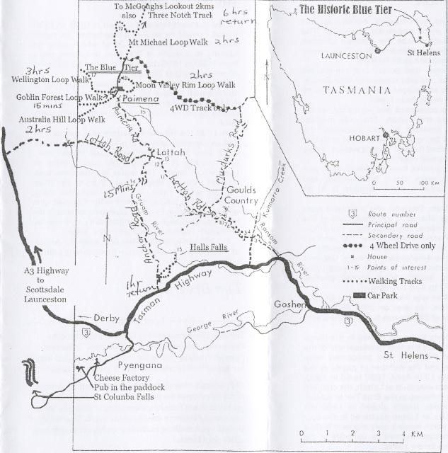
Goblin Forest Walk (20 min)
Interpretation
signs along the walk explore the history of the Blue Tier. This walk
is great for those who do not have much time but want to stretch their
legs and learn about the 'mountain of tin'. The walk is of wheelchair
standard. (follow green markers)
If you do not have much time and want to get a good view of the area, try the 30 minute return walk to the top of Mt. Poimena. It is a short and steady climb to the summit. Walkers are rewarded with spectacular views over St. Helens and the coastline beyond so remember to bring your camera! (follow blue markers to the trig point)
moderate walks
Moon Valley Rim Loop Walk (2 hours)
The walk
takes you to the summit of Mt. Poimena then along Moon Valley Rim and
Blue Tier Battery before returning via the Sun Flats Road. (follow blue
markers)
Australia Hill Loop Walk (2 hours)
This walk
passes through open country and stands of regenerating rainforest and
is great for visitors who want to see some remnants of the mining era.
Look for abandoned machinery at Summit Mine and Harry Moses' (the last
Blue Tier miner) sluice box at the Compere Mine. (follow orange
markers)
Wellington Loop Walk (3 hours)
Begins at the
halfway mark on the Goblin Forest Walk. The walk is great for those
interested in the history of the Blue Tier because it takes you past
interesting remnants of the mining days. The walk passes through a
diversity of vegetation types including regenerating rainforest,
patches of remnant rainforest and sphagnum bogs. (follow red
markers)
October 2017: The bridge across Wellington Creek is
no longer functional.
Mt. Michael Loop Track (2 hours)
Begins at the
Sun Flats Road. The walk passes through rainforest before climbing up
to the summit of Mt. Michael. Walkers are rewarded with fantastic
views. On the way down stop and look at the Mt. Michael Mine which was
one of the largest mines in the area. (follow yellow markers)
hard walks
Three Notch Track - return (6 hours)
Follows
an old pack trail to McGoughs Lookout and return. Walkers are rewarded
with spectacular views of the coastline. The walk is long and
difficult and should only be attempted by experienced walkers. (follow
yellow and red markers)
Three Notch Track - complete (added 2008/07/12): This track has recently been upgraded by Forestry Tasmania and it is now possible to hike from Sun Flats to the bottom end near Pioneer. However this requires having a vehicle at the other end to pick up walkers.
There are other walks that can be undertaken on the Blue Tier. If you would like to do these walks we suggest you talk to the staff at the St. Helens History Room.
More Information: contact the staff at the St. Helens History Room and Visitor Information (03 6376 1744).
(Brochure was produced with assistance from Forestry Tasmania)
Blue Tier Map or map of a larger area or the St. Marys region for other activities.